 Medieval Frontiers and Fortification: The Pale and its Evolution
Tadhg O’Keeffe
Dublin City and County: From Prehistory to Present (1992)
Moreover, the English have now a greater advantage than at the Conquest, for then there were not five piles or castles in all Ireland, where at this day there are no less than 500 (Patrick Finglas, 1515) 1
Frontiers are indeed the razor’s edge on which hang suspended the modern issues of war and peace (Lord Curzon, 1907) 2
Introduction
The frontier model formulated by Frederick Jackson Turner a century ago is an outstanding contribution to our understanding of pattern-process relationships behind the cultural landscape.3 Turner’s vision of an American frontier, and its translation into a challenging model of a whole spectrum of spatial configurations, has engendered schools of empirical and theoretical research.4 The frontier concept is well known to historical geographers and it is a theme from which medievalists in particular cannot escape. Lydon and Duffy have expertly shown the value of addressing the issue of the frontier specifically 5 rather than `allow it speak for itself as many recent writers have done,6 but the potential of the concept has by no means been fully realised. This chapter explores the frontier concept in a manner which is designed to augment the observations of Lydon and Duffy. Its principal aim is to use the concept as a lens through which we can focus on the form, function and significance of medieval fortifications in the landscape of the region around Dublin.
For the purpose of this chapter, counties Dublin, Wicklow, Kildare, Meath and Louth constitute the `Dublin region’. The rationale is that four of these counties were largely contained within the pale boundary at the end of the fifteenth century and shared an architectural tradition. Wicklow demands inclusion through its proximity to the nerve-centre, Dublin city, and because its mountain core so influenced the historical geography of Dublin and Kildare. In earlier centuries this region does not cohere with the same historical sanction as in the fifteenth century, but the mottes within it can quite legitimately be compared with each other, and nowhere in Ireland can a more important group of con–trasting Norman stone castles be seen than that within a radius of 50km of Dublin.
[smartads]
Castles of the Anglo-Norman frontier
A frontier is `a concept of zone’,7 a zone at the edge or at the front of something; it is, quite literally, the `front tier’. As a term it is custom-built for the intangible phenomenon of a space which exists primarily in the mind. As Lattimore has written, `only after the concept of a frontier exists can it be attached by a community that has conceived it to a geographical configuration’.8 Translated into the context of the Norman invasion of Ireland, a frontier can legitimately be conceived of as the interface between native and alien populations. Differences between the two populations found landscape expression in activities such as farming practices and domestic architecture, but the frontier condition was specifically articulated in symbolic form by the castle. The very existence of an encastellated frontier landscape – `one of the first systematically fortified frontiers in Europe’ 9 – tells us less about the threat of the Irish to the colony than it does about Norman per–ceptions. Turner, in a similar sense, created the American frontier when he conceptualised the outer edge of population movement as `the meeting point between savagery and civilisation’.10 If a frontier is a concept of space, perception is its dynamic.
A frontier implies a centre, just as a periphery implies a core.11 Here we are dealing with matters of scale. At the Norman invasion, England, Wales and arguably France, constitute a core to which Ireland is peripheral, a centre to which Ireland is a frontier. This is evident in the castles constructed in the early stages of the colonisation: compared to contemporary castles of the secure lands in England and Wales, those castles built in the initial stages of the colonisation of Ireland are traditional earthwork types. The difference between the castle of a powerful lord and that of a lesser lord is one of scale; the essence is the same. Once the process of colonisation is underway within this large-scale frontier, Dublin and the leading seigneurial settlements might themselves be said to constitute cores or centres, since they are the equivalents to, if not the surrogates of, the secure settlements of the colonists’ homelands. The smaller baronial settlements are peripheral to or at the frontiers of these centres or cores. This shift in the scale and geography of the core/periphery or centre/frontier foci is also expressed in the castles: Dublin and other major settlements acquire stone castles, some of them highly sophisticated works of architecture by contemporary standards elsewhere, while smaller baronial settlements continue to have older, more traditional, earthwork castles.
Mottes and ringworks
The great majority of Norman castles built in the first few decades after the invasion were of earth and timber. These were favoured materials because of the speed with which castles could be erected;12 this also predicated the customising of pre-existing earthworks.13 Early castles were of two principal types: mottes and ringworks.14 Comparatively little is known about the ringwork castle, not least in the Dublin region where only five have been tentatively identified in the most recent publications;15 environmental factors may influence the comparative rarity of the form,16 but ultimately the explanation of their absence may be that of the two basic forms of earthwork castle available to them, castle-builders in the Dublin region chose to build mottes, of which there are many examples in the region.17
Even though it was largely out-of-date as a castle-type in contemporary Europe,18 the motte was valuable to prestige-conscious Normans because it elevated solars (private bed-sittingrooms of castle owners, generally contained within towers) and halls, thus rendering them widely visible. The largest examples – among them some of the largest in Europe at over ten metres in height – were associated with the principal Norman land grants and invariably have baileys.19 Given the comparative rarity of moated sites in the Dublin region,20 one might speculate that the motte continued to be built so late that the phase of moated site building was largely by-passed. The function of the classic moated site – the protection of small manorial farmsteads – may have been usurped by smaller mottes; of the few moated sites in the area, those at Drimnagh (Dublin) and Castlewarden (Kildare) may have been equivalent in function to the larger mottes.21 Mottes may even have stayed in use until the tower-houses of the fourteenth and subsequent centuries were built.
A medieval castle rooted in the landscape had little power of obstruction in territorial defence,22 but a territory could be well–protected by co-ordination of castle locations within it.23 Such a strategy is indicated by the location of mottes in the Dublin region and can be demonstrated by representing the distribution pattern of mottes in terms of hypothetical defended zones of a regular radius of 6.5km.24 This radius has been estimated on the model of the mottes of modern county Dublin, where regular spacing is especially well-marked on the north side of the river Liffey. Mottes constitute a protective cordon around the city and the one gap is filled by Dundrum Castle, a thirteenth-century stone castle. There is also a stone castle on the motte at Castleknock. The average distance between mottes in west Wicklow and east Kildare is a little less In north Meath and north Louth, mottes are closely spaced, with the average distance between them being two and a half kilometres. Curiously, in this part of the region castles are almost all located at a short distance from county boundaries rather than on them, but environmental factors may partly explain this: by comparing the location of mottes on Figure 1 with the topographical features marked on Figure 3 it can be seen that most mottes are found among glacial drumlins and kames. This undulating landscape had many corridors along which the Irish could penetrate the colonial territories, but equally it provided many naturally elevated sites for castles; glacial features were often exploited by Norman castle-builders for that very reason, the earthworks in most cases being largely scarped away from the natural ridge rather than built-up from ground level. Across the centre of Meath where mottes are, on average, about four kilometres apart, the architecturally related stone castles at Trim (Meath) and Maynooth (Kildare) are located at consistent distances from mottes.
Although it was not used exclusively for frontier purposes, the motte can validly be considered as a frontier castle type in Ireland, because it was the earthwork chosen for the primary castles of the colony. Using the recorded dates of mottes in Meath, Graham has reconstructed a series of frontiers moving rapidly from the east coast to the Shannon.25 Indeed we tend to think of the spread of the Normans from east to west in terms of a linear progression. On a regional level, using Dublin and Kildare evidence in particular, a less linear and more nodal frontier model seems appropriate: ancient territorial units were claimed by the Normans more or less simul–taneously, thus becoming nominally Norman, and then the colony was established successfully by growth outwards from the centres to the edges of these primary or seigneurial manors. On a supra-regional level, the Norman colony had reached the banks of the Shannon by the time Dublin city had been fully ringed by castles, thus indicating that colonial expansion was not precluded by the lack of adequate fortification in those areas which had already been taken over.26
Stone castles
The really prestigious castle type, in the frontier region as elsewhere, was the stone castle. The number of these built in the twelfth and thirteenth centuries in the Dublin region is difficult to estimate. Glasscock mapped fourteen in the five counties 27 but not all these sites currently possess fabric demonstrably of that date, while other sites probably have early fabric awaiting identification; at Dundrum Castle (Dublin), for example, early fabric was revealed in excavations which began in 1987.28 The total number of stone castles built in the region could be much greater than Glasscock’s total.
There are substantial remains of at least three castles of the period in county Dublin: Dublin Castle itself, Castleknock and Swords. The latter is the most unusual. Founded around 1200, it is an episcopal castle comprised of an extensive and barely fortified enclosure.29 While some doubt can be expressed about attribution of parts of its fabric and plan to so early a date, it appears to be a genuine example of a lightly fortified, early thirteenth-century castle. Not very far beyond Dublin’s county boundary in Meath and Kildare are the major castles of Trim and Maynooth, as well as possible survivals of early plans or fabric at Dunsany (Meath) and Leixlip (Kildare). Four castles in Wicklow are marked by Glasscock.30 Of those in Louth, Carlingford Castle is most pertinent to buildings close to Dublin city since it com–pares in aspects of its lay-out to Maynooth and especially to Trim.31
At least two stages in the history of castle architecture are represented by all these castles: an early stage in which castles are dominated by keeps, and a subsequent stage in which the keep is phased-out as the military and residential focus, with more emphasis placed instead on the form and layout of the enceinte (enclosure). This design transformation occurred in the royal domains of France and England in the late twelfth and early thirteenth centuries, exactly the time when the first stone castles were being built in Ireland.32 Three castles in the Dublin region in which this transformation is evident, Castleknock, Trim and Dublin, are discussed here.
Castleknock
Although Leask implied that there was now little to see at Castle–knock,33 half of Hugh Tyrell’s great castle of c.1200 survives reasonably intact. It was fairly well preserved at the end of the seventeenth century.34 The castle is a massive double-ramparted oval motte sur–mounted by the remains of a towerless enceinte wall with a polygonal keep along its circuit. The keep stands on a slight rise at the east end and appears to have been built before the enceinte wall, although the interval may not be a significant one. There is evidence that the area within the enceinte was partially roofed over in the manner of a shell–keep.35 Castleknock’s architecture, still awaiting detailed study, is best understood in the context of a small body of late twelfth/early thirteenth-century English work.36 While it is important as one of the earliest stone castles in Ireland, and is thus indicative of that refinement in the identity of the Irish frontier which is expressed by stone castles, Castleknock’s architecture is traditional, with no concessions to new planning ideas which were appearing elsewhere at the time that it was built.
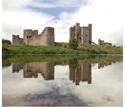
Trim
The celebrated twenty-sided keep at Trim, comprised of a square block with turrets projecting from the middle of each face, was begun, perhaps as a hall-keep, before 1200 and extended upwards to become a tower-keep some time early in the following century.37 At Maynooth an enormous hall-keep was started as late as 1203,38 and built to a not-unrelated design, with shallow pilasters containing small chambers projecting from the centres of three of its four faces. Contemporary with the lower part of the Trim keep are three rectangular towers and adjoining stretches of curtain wall on its north side. The original curtain walls of Maynooth were apparently of a similar form. An early curtain wall at Carlingford, dating to around 1200, compares closely with that at Trim, and together they compare with early work at Ludlow (Shropshire), the de Lacy caput in the March.39
The design of Trim’s keep can be understood in the context of keep design of the previous generation in England, and principally in the design of some royal keeps,40 but as a building conceived around 1200 it is a little out-of-date. While it is a late and sober product of an essentially experimental age in castle-architecture,41 those experiments usually aimed at alleviating such obvious problems as Trim actually accentuated: numerous passages through the wall which reduced its thickness, and abundance of corners which could be broken down in an assault. Yet to emphasise its archaic quality would be a little unfair: there was clearly a time-lag factor because the de Lacys and other baronial families were not immediately aware of new French developments.
The new ideas arrived in Trim around 1220 or shortly after, as is evident in the construction of the remainder of the curtain wall as a great sweeping curve furnished with open-backed cylindrical towers and a barbican, concepts originating on French soil.42 Nowhere in Ireland, not even at Carrickfergus (Antrim), is the essence of the late twelfth/early thirteenth-century planning transformation better exemplified than at Trim. However, for a complete product of this `new era’ of castle-planning and for an even firmer indication of the role of France in effecting these architectural changes in Ireland, one can turn to Dublin Castle.
Dublin
This royal castle was built under the authority of King John after the justiciar, Meiler FitzHenry, complained that there was no place in which the royal treasure could safely be stored. The writ authorising its construction `with good dykes and strong walls’ was issued in 1204.43 Later refurbishment of the castle has robbed us of much of the medieval fabric but fortunately seventeenth-century plans survive 44 and this information, taken with extant and excavated structural evidence,45 indicates a castle of the first rank.
Dublin’s form – a roughly rectangular enclosure with four very substantial cylindrical towers at the corners, a twin-towered gateway in the centre of one long wall and a small turret near the centre of the opposite long wall – is typically early thirteenth-century and is absolutely up-to-date by international standards. Its progenitors are to be found in France rather than in England. Castles of regular quad–rangular plan had emerged in France by the time the Normans were arriving in Ireland;46 around 1200, these concepts cross-fertilised with new ideas introduced onto French soil at Chateau Gaillard (Sure). These ideas flowered into such sophisticated enceinte forms as the Louvre in Paris and Yevre-le-Chatel (Loiret).47 The construction of Dublin is roughly contemporary with these marvellous French works, but no one castle may be cited as its specific source.
Dublin’s plan has been compared to that of Le Coudray-Salbart (Deux-Sevres) by Knight.48 There is a point of similarity not noted by him upon which it is worth reflecting. Some French castles which are a little later in date but essentially of the same generation as Dublin – Dourdan (Essonne) and Nesles-en-Tardenois (Aisne), for example – had keeps incorporated on their defended circuits rather than isolated within them.49 At both Le Coudray-Salbart and Dublin, one corner tower is larger than the others; as that at the French castle appears to have functioned as a keep,50 so too might the Record Tower at Dublin Castle.
Dublin Castle might well be the first castle in these islands built ab initio in the new manner. That there is nothing directly comparable and of the same date in England or Wales, the area which one would consider on historical grounds to be the `centre’ to which the Irish frontier is attached, illustrates the complexity of these concepts. The building of mottes long after other societies had adopted other monument forms, and the traditional, if not archaic, architecture of stone castles such as Castleknock and Trim suggest that the colony in Ireland was truly peripheral. On the other hand, Dublin Castle and the second phase of Trim Castle are entirely modern. Despite their location on the edge of Europe, stone castles of the Irish frontier were at the vanguard of developments after 1200.51
The pale frontier
War was endemic in fourteenth-century Ireland. The idea of a `shifting frontier’, a phrase often used in the literature to describe the spatial dimension of the effects of the fourteenth-century wars on the colony,52 needs to be contextualised in both geographical and sociological dimensions. On the one hand, it accurately expresses a spatial relocation of the periphery; from an anglo-centric point of view, that movement is a contraction. On the other hand, the frontier `shift’ expresses a social-cultural transformation. In the same way as a frontier implies a centre in spatial terms, a frontier community identifies culturally with the community of the centre. But, as Sahlins has noted in his work on tribal society, `peripheral communities develop close relations and cultural similarities with neighbouring peoples, setting in motion a marginal erosion of tribal integrity, and rather than a definite intertribal border one comes upon an ambiguous zone of transition.’53 Frontier-centre models have a distinctive diachronic character, with the frontier either failing or developing into a full culture: 54 the media natio in Ireland would seem, in part, to be a product of such a process.55
During the fourteenth century, a new type of castle, the tower-house,56 appeared on the landscape. Its form represents a trans–formation in castle architecture: the decentralised planning of late thirteenth-century castles was reversed and the emphasis returned to a single building with accommodation arranged vertically within it. But the tower-house, even in the 1300s, was not confined to the areas which possessed large castles; rather, it is a settlement form common to the whole island. In terms of their functions and settings, the tower-houses of the Dublin region were typical: most were defended farm–houses;57 others were rural fortifications 58 or defended residences of wealthy priests 59 and townspeople.60 The origins of the tower-house is an unresolved question 61 but its ubiquity testifies most graphically to cultural transformation.
The dilution of royal authority in the Dublin region was given specific spatial dimensions in 1435 when it was reported to the king that his writ was confined to an area thirty miles long and twenty miles wide in counties Dublin, Meath, Louth and Kildare.62 This area was known as the pale. By its very nature – a `concept of zone’, a periphery – it was a frontier. It was even perceived as such by the contemporary Irish, who were familiar with its geography and its name.63 Typically for a frontier, its edges were fuzzy rather than sharply defined: at the extremities of the area, social and cultural interaction took place to the extent that some English castles had Irish constables and guards.64 However, we should be careful not to separate too crisply a centre and periphery in the pale: government was centralised but mobile,65 and the subsidies that it offered for the building of castles 66 applied to all parts of the area and not just to the geographical extremities.
The frontier was assigned a boundary – albeit on paper rather than on the landscape – by an act of parliament in 1488-9.67 This boundary delimited an area of much the same dimensions as that described in 1435 and is mapped in Figure 3. Nicholls has reconstructed a larger area beyond the pale as the maghery, the area within which common law and the authority of the Dublin administration functioned,68 and this too is mapped in Figure 4. The line of the pale boundary has two features which indicate that the authors of the 1435 report and of the act of 1488-9 were well-informed about the distribution of English settlement. Firstly, in central Meath and Louth the boundary runs through the belt of glacial kames and on the south side of the drumlin belt. This was a natural geographical boundary.69 It might be noted that the ring-forts for which Graham and Barrett have suggested possible contemporaneity with the pale 70 are clustered along the kame and drumlin belt and are not necessarily related to the presence of the pale. At the other end of the region, in Dublin and Kildare, the line runs through an area with a very high density of castles,71 the highest density being in the countryside within and around the bend of the Liffey at the pale’s southern extremity. Most of these castles are tower-houses and it is clear from the documentation that most were built before the statute of 1488‑9.
The tower-houses marked the area of the frontier by their numerical quantity and architectural quality. Although not substantially different in architecture from most tower-houses, they possessed one recurring feature – the projecting turret – which distinguished them from other traditions of Irish tower-house architecture, the principal exception being that of east Down.72 This turret occurs singly or in groups of two, three and four, and contains the ascending stairs and/or small chambers such as garderobes. In plan it is square or slightly rectangular, U-shaped or cylindrical. The most impressive tower-houses are those with four corner turrets.73 Paired turrets are usually, though by no means always, at opposite corners of the buildings. The majority of square turrets do not clasp a corner of the building but project to one side and are flush with one of the walls, as at Portrane (Dublin).74 Turrets are found on an estimated 60% of tower-houses in county Dublin, 75% in county Meath and 90% in county Louth.75 The remainder of the tower–houses in the area are simple square or rectangular buildings, but close inspection invariably reveals small details comparable with those in the turreted tower-houses. This tradition of tower-house architecture may be termed the `pale tradition’ on account of its clustering within the four counties, but it is pertinent to note that no line can be drawn around the distribution of `pale tradition’ tower-houses which will completely exclude tower-houses of other forms.
For most of the fifteenth century the frontier zone known as the `inglishe pale’ was manifest in the tower-houses described above. The frontier had no tangible boundaries in the cultural landscape before 1494 when, by an act of Poyning’s parliament, the area which had been defined as the pale in 1488 was to be enclosed with a ‘double–ditch of six-foot of earth above the ground.’76 A number of places had protective ditches (rural counterparts of town walls), erected earlier during the century 77 but this was an attempt to shore-up the contracting area within a single defensive entity.
The pale boundary earthwork
The problems of identifying medieval earthworks in the contemporary landscape are considerable.78 In upland areas of Dublin and Kildare some fossil field boundaries might be identified as parts of the pale earthwork. Excavation of a bank and ditch in Cupidstown (Kildare) revealed the former existence of a palisade on top of the bank;79 this is likely to be part of the medieval boundary. Earthworks close to the church at nearby Kilteel might also be part of the boundary;80 a repre–sentative cross-section illustrated in Figure 2 shows a low, denuded bank with wide, shallow outer ditches and low outer banks.
Tradition, through the medium of the Ordnance Survey, records that some linear field boundaries around the region are parts of `the pale’. A cross-section of the boundary at Clongoweswood (Kildare), fairly typical of the traditionally-identified `pale’, is illustrated in Figure 2. It is a high, flat-topped bank, wide enough for use as a pathway, flanked by deep ditches which have obvious signs of having been re-cut. Similar boundaries, not traditionally identified as parts of `the pale’, are preserved within later land enclosure systems, as at Coughlanstown and Bishopsland (Kildare), for example. The Clongoweswood and Kilteel earthworks illustrated in Figure 2 are very different morphologically, and that difference cannot be explained by severe denudation in the case of the latter; this does not preclude the possibility that the earthworks represented at Clongoweswood, Kilteel and Cupidstown are all part of the medieval boundary.
Such is the width of the Clongoweswood-type boundaries that most of them functioned as accessways up to modern times. In describing the pale boundary in Dublin as an `old double-ditch and pathway’, Joyce notes that it was `the route taken by the Corporation in ancient times, when riding the franchises or boundaries of their municipal jurisdiction.’ 81 Such a use for `the pale’ may not be without medieval precedent. In the fifteenth century `a dyke’ had been constructed to protect a stretch of country between the chapel of St Bride near Tallaght to Saggart and in 1475 it was ordained that `no road shall be made on, in, by or over the dyke’;82 this indicates that the ‘dyke’ is probably a bank (on) and ditch (in) of some size, and it suggests a propensity among local populations to use such features as roadways.
If the old earthwork functioned in the middle ages as an accessway, it is possible that in certain parts of the region it has been removed and replaced, on exactly the same line, by more modern roads. This is the case in Neillstown (Meath), centrally located between Trim, Kildalkey and Athboy, where a modern gravel and tar laneway, on the west side of and parallel to the Tremblestown river, is identified by the Ordnance Survey and by local tradition as `the pale’. The laneway runs for about 750m with its line continued by a single ditch at one end and by a bank and two ditches at the other, giving a total length of about 1,300m. Fifty years ago this laneway was a narrow trackway with cultivation ridges, probably lazy-beds, diagonally across it.83
Neillstown illustrates one of the problems of identifying the medieval boundary in the modern landscape. It also illustrates the need for caution. On a map, the Neillstown laneway has the location and orient–ation one might expect: it is exactly in line between Trim and Athboy. However, its surface is level with that of the surrounding fields and that appears to have always been the case. Moreover, when it was a mere trackway, the lazy-beds ran diagonally across it, suggesting they were part of a cultivated field cut by the trackway; in the present state of our knowledge those lazy-beds are more likely to be post-1500 than pre–1500. The laneway is not a very convincing contender.
A further problem faced by the investigator is orientation. One might assume from the description that the earthwork ran more or less in a line from one location to the next, but the field evidence indicates otherwise. In Kildare, for example, about 3,500m of putative earth–work survives in contiguous townlands north of Rathcoffey. In the part of this area shown in the plate – Ballyloughan, Clonduff and Graigue–pottle townlands – it is orientated north-south before turning east–west; further along it swings to the south and then turns again to the east. If this is a genuine relict feature of a pre-modern landscape one must conclude that it, and other examples around the region which are of unexpected alignment, enclosed an individual’s property. This suggests to us that in some, if not most, cases, the construction of the pale earthwork was undertaken under the terms of the statute but with private gain in mind.
In advance of a full report on the field evidence, the location of the earthwork is summarised here. Joyce describes the boundary in the Merrion-Donnybrook area of Dublin.84 There is a possible section in Balally townland, south of Dundrum.85 In Kildare a section of the earthwork was excavated at Cupidstown, near Kilteel, and in Kilteel itself some of the earthworks near the church have been identified as part of the pale. We know the boundary ran southwards to Ballymore via Rathmore. It may have partly followed the line of the present roadway, the `public street which came from Radmor near the castle of Du’naud to the river of Auenlife’,86 or it may have been at a higher altitude: possible stretches are found on the south side of Cupidstown Hill and to the east of Barretstown Castle. If the latter route is the correct one, it would have approached Ballymore Eustace on the east side, and indeed east of Ballymore Eustace are other possible stretches.87 To the west of Ballymore a substantial stretch runs across towards Coughlanstown in the direction of Harristown. It can be picked up again on the north side of Clane in Clongoweswood,88 Rathcoffey, and in a cluster of townlands to the north-east of Clonshanbo, including that part which is illustrated in the plate. In Meath there is the roadway in Neillstown, between Trim and Athboy, a stretch in Ballynamona, between Athboy and Kells,89 and another stretch running north from Siddan, a place mentioned in 1488-9 where tolls were to be collected in order to `wall, enclose and pave’ the town in 1476-7.90 In Louth there is a possible stretch at Cardistown.91
Conclusion
It is very unlikely that the pale earthwork was ever completed. The actual process of constructing the earthwork is apparently not mentioned in the years after the act, although one might expect it to be, given the scale of the undertaking. The pale area shrank considerably in the early fifteenth century. In 1535 Justice Luttrell described the area outside which the gentry exacted coyne and livery; a good guide to the spatial parameters of the pale, this indicates an area considerably smaller than that defined in 1488.92 The old frontier continued to shrink in size. If there is a point to be made arising out of the phenomenon of the pale, it is that frontiers cannot be neatly defined by lines either on maps or in landscapes. Frontiers exist because societies create them, and they undergo natural transformation, even to the point of disappearing, through social processes.
End Notes
1. Cal. Carew MSS 1515-74, p. 5.
2. Cited by J. Prescott, Political frontiers and boundaries (London, 1987), p. 5.
3. F. Turner, The frontier in American history (New York, 1953).
4. These are summarised by W. Norton, Historical analysis in geography (London, 1984), pp 95, 101-2, and R. Burns, `The significance of the frontier in the middle ages’, in R. Bartlett and A. MacKay (ed.), Medieval frontier societies (Oxford, 1989), especially pp 307-17.
5. J. Lydon, `The problem of the frontier in medieval Ireland’, in Topic: A journal of the liberal arts, xiii (1967), pp 5-22; P. Duffy, `The nature of the frontier in medieval Ireland’, in Stud. Hib., xxii-xxiii (1982-3), pp 21-38; B. Smith, `The medieval border: Anglo-Irish and Gaelic Irish in late thirteenth and early fourteenth-century Uriel’ in R. Gillespie and H. O’Sullivan (ed.), The Borderlands. Essays on the history of the Ulster-Leinster border (Belfast, 1989), pp 41-54.
6. Preface to Bartlett and MacKay (ed.), Medieval frontier societies, p. v.
7. J. Gottmann, The significance of territory (Charlottsville, 1975), p.134.
8. O. Lattimore, Studies in frontier history. Collected Papers 1928-1958 (Oxford, 1962), p. 47.
9. Lydon, `Problem of the frontier’, p. 5.
10. F. Turner, Frontier and section (New Jersey, 1971), p. 38.
11. R. Paynter, `Surplus flow between frontiers and homelands’ in S. Green and S. Perlman (ed.), the archaeology of frontiers and boundaries (London, 1985), p.165; see also A. Simms, `Core and periphery in medieval Europe: the Irish experience in a wider context’, in W. Smyth and K. Whelan (ed.), Common Ground. Essays on the historical geography of Ireland (Cork, 1988), pp 22-40.
12. The evidence of the Bayeux Tapestry indicates that the motte at Hastings was raised within two weeks: see A. Taylor in `Discussion du Rapport I (La motte), Les fortifications de terre en Europe occidentale du Xe au XIIe siecles’ in Archeologie Medievale, xi (1981), p.29.
13. For examples of this in Ireland, see T.Barry, The archaeology of medieval Ireland (London, 1987), pp 40-2; in Britain it is encountered at Aldingham (Lancashire) and Rumney (South Glamorgan): Medieval Archaeology, xiii (1969), pp 258-9; xxiii (1979), p.263, and in France at Sebecourt (Sure): J. Decaens, `L’enceinte fortifiee de Sebecourt (Eure)’, in Chateau Gaillard, vii (1977), pp 49-65.
14. For mottes and ringworks see Barry, Medieval Ireland, pp 37-54, and T. O’Keeffe, `The archaeology of Norman castles in Ireland. Part I: mottes and ringworks’, in Archaeology Ireland, iv, no. 3 (1990), pp 15-17.
15. The sites listed by Barry, Medieval Ireland, are Trim Castle and Clonard (county Meath), Pollardstown (county Kildare), Kilmartin Castle (county Wicklow). Ardscull (county Kildare) is suggested by O’Keeffe, `Mottes and ringworks’.
16. This is the case in Wales: C. Spurgeon, `Mottes and castle-ringworks in Wales’, in J. Kenyon and R. Avent (ed.), Castles in Wales and the Marches (Cardiff, 1987), pp 32-6.
17. D. Cathcart King and L. Alcock, `Ringworks in England and Wales’, in Chateau Gaillard, iii (1969), pp 103, 106; Spurgeon, `Mottes and castle ringworks’, pp 37-8.
18. Archeologie Medievale, xi (1981), pp 8-11; significantly, the only other part of Europe which has motte-building at such a late date is south-west France, outpost of the Angevin world in the 1200s: see J. Gardelles, Les chateaux du moyen age dans la France du sud-ouest (Paris, 1972).
19. For size-function relationships, see especially B. Graham, `The mottes of the Norman liberty of Meath’ in H. Murtagh (ed.), Irish midland studies (Athlone, 1980), pp 39-56, and Ibid., Anglo-Norman settlement in Ireland (Athlone, 1985), pp 12-13.
20. Few moated sites are indicated by the map of rectangular earthworks compiled by R. Glasscock, `Moated sites and deserted boroughs and villages: two neglected aspects of Anglo-Norman settlement in Ireland’, in N. Stephens and R. Glasscock (ed.), Irish geographical studies (Belfast, 1970), p.165.
21. The moat at Drimnagh incorporates a stone castle of Rigold’s Class B (S. Rigold, `Structures within English moated sites’, in F. Aberg (ed.), Medieval moated sites (London, 1978), pp 30-3); for Castlewarden see D. Hall, M. Hennessy and T. O’Keeffe, `Medieval settlement and agriculture at Oughterard and Castlewarden, county Kildare’, in Ir. Geog., xviii (1985), pp 20-1. The replacement of mottes by moated sites has been suggested by B. Colfer, ‘Anglo-Norman settlement in Wexford’, in K. Whelan (ed.), Wexford: history and society (Dublin, 1987), p. 81.
22. See also D. Cathcart King, Castellarium Anglicanum, vol i (London, 1983), p.xxi.
23. Giraldus Cambrensis described the strategy: Expugnatio Hibernica (Dublin, 1978), p.249.
24. The map was compiled from the following sources: M. Moore, Archaeological inventory of county Meath (Dublin, 1986); V. Buckley, Archaeological inventory of county Louth (Dublin, 1987); G. Stout et al., Sites and monuments record county Wicklow (Dublin, 1986); Sites and monuments record county Kildare (Dublin, 1988); Sites and monuments record county Dublin (Dublin, 1988). These were supplemented with the published lists by R. Glasscock, `Mottes in Ireland’, in Chateau Gaillard, vii (1977), pp 95-110, and D. Johnson, Dublin castles, The resource source, no. 13 (Dublin, 1988).
25. Graham, `Mottes of Meath’.
26. T. O’Keeffe, Archaeological aspects of twelfth and thirteenth‑century Irish castles, Lecture to Dublin Historical Settlement Group, 1989.
27. New History of Ireland, viii, map 36, p. 34.
28. E. O’Brien, `Excavations at Dundrum Castle, Dundrum, county Dublin’, in Archaeology Ireland, iii, no. 4 (1989), pp 136-7.
29. H. Leask, Irish castles and castellated houses (Dundalk, 1973), p. 72.
30. Kindlestown, Newcastle, Castlekevin, Wicklow and, in the far south, Arklow. Kindlestown is recorded as a hall (P. Harbison, Guide to the National Monuments of Ireland (Dublin, 1970), p.258).
31. The other two sites are Ardee and Castleroche.
32. S. Toy, Castles. Their construction and history (New York, reprint, 1984); A. Chatelain, Chateaux Forts. Images de pierre des guerres medievales (Paris, 1987); T. O’Keeffe, `The archaeology of Norman castles in Ireland. Part II: stone castles’, in Archaeology Ireland, iv, no. 4 (1990), pp 20-22.
33. Leask, Irish castles, p.43.
34. It was depicted by Francis Place in 1698: ibid..
35. Garderobe outlets indicate that there was some residental accommodation at a high level along the inside of the north wall of the enceinte, and Place’s depiction shows a high enceinte wall with fenestration on the south side indicating residental accommodation here also. The keep was clearly entered at first floor-level, possibly from one of the buildings around the inside of the enceinte wall.
36. English keeps which are polygonal inside and outside, as is the pattern at Castleknock, include Chilham (Kent), built between 1171-4; Tickhill (Yorkshire), built between 1179-82; Odiham (Hampshire), built between 1207-12: D. Renn, Norman castles in Britain (London, 1973), pp 142, 263 and 322-3. Shell-keeps were being built in England after 1200, as at Trematon (Cornwall) and Tonbridge (Kent): C. Platt, The castle in medieval England and Wales (London, 1982), p.28. Another comparable castle is Gisors (Eure), where Henry Il added a polygonal keep to the edge of an earlier shell keep: A. Chatelain, Chateaux forts et feodalite en Ile de France du Xleme au XIIIeme siecle (Nonette, 1983), pp 197-9.
37. For the history of the castle and an assessment of its architectural history, see P. Sweetman, `Archaeological excavations at Trim Castle, county Meath 1971-4′, in R.I.A. Proc. lxxviii (1978), C, pp 127-98; a date of 1212-20 is suggested for the keep by R. Stalley, Architecture and sculpture in Ireland 1150-1350 (Dublin, 1971), p.33.
38. Harbison, Guide, pp 123-4, and references therein.
39. D. Renn, `Chastel de Dynan: the first phases of Ludlow’, in Kenyon and Avent (ed.), Castles, pp 59-60; O’Keeffe, `Stone castles’.
40. Relevant buildings include Kenilworth (Warwickshire), built c.1170, Dover (Kent), built 1180-90 and, especially pertinent to Trim, Orford (Suffolk), built 1167-9: see Platt, Castle, pp 35-9, 41-3. Towers (of great depth in the case of Orford) containing private accommodation project from the corners and/or wall faces of these castles. There are parallels for the Trim keep at a later date on Lundy Island (Devon) and at Warkworth (Northumberland); square towers were added to the keep of Castle Rushen (Isle of Man), one time property of John de Courey’s brother-in-law. (Renn, Norman castles, p.68).
41. Platt, Castle, p.34.
42. There are several possible origins in both England and France for the open–backed cylindrical tower; it appears to be fully developed at Beaumont-sur-Oise (Val d’Oise) in the 1220s (plan: Chatelain, Ile de France, p.330). The Trim barbican (and the gate-tower at Dunamase in Laois) is paralleled at Le Coudray-Salbart (Deux-Sevres): J. Knight, `The road to Harlech: aspects of some early thirteenth-century Welsh castles’, in Avent and Kenyon (ed.), Castles in Wales, p.79. Originally Trim may have had, or was intended to have, a lozenge-shaped enclosure with the keep, on top of a low mound, occupying the south corner.
43. References and additional material are given by R. Stalley, `William of Prene and the royal works in Ireland’, in Brit. Arch. Assoc. Jn., exxxi (1978), p.32.
44. J.B. Maguire, `Dublin Castle: Three centuries of development’, in R.S.A.I. Jn., cxv (1985).
45. A. Lynch and C. Manning, `Dublin Castle – the archaeological project’, in Archaeology Ireland, iv, no. 2 (1990), pp 65-8.
46. Chatelain, Chdteaux Forts, pp 30-1.
47. Chatelain, Ile de France, pp 297-300, 311-7.
48. Knight, `Harlech’, p.79.
49. Chatelain, Ile de France, pp 319-25, 355-9.
50. P. Curnow, `Some developments in military architecture c. 1200: Le Coudray-Salbart’, in R. Brown (ed.), Proceedings of the Battle conference on Anglo-Norman studies, ii (1979), p.45.
51. O’Keeffe, `Stone castles’.
52. T. Barry, `The shifting frontier: medieval moated sites in counties Cork and Limerick’, in F. Aberg and A. Brown (ed.), Medieval moated sites in north‑west Europe (Oxford, 1981), pp 71-85.
53. M. Sahlins, Tribesmen (New Jersey, 1968), p.16.
54. Paynter, `Surplus flow’, pp 165-6.
55. J. Lydon, `The middle nation’, in J. Lydon (ed.), The English in medieval Ireland (Dublin, 1984), pp 1-26.
56. The tower-house is discussed in Leask, Irish castles, pp 75-124, in C. O Danachair, `Irish tower houses’, in Bealoideas, xlv-xlvii (1979), pp 158-63, and in C. Cairns, Irish tower houses: A county Tipperary case study (Athlone, 1987). It should be noted that the tower-house is not the only form of castle to appear in this period: see T. O’Keeffe, `Rathnageeragh and Ballyloo. A study of stone castles of probable 14th to early 15th century date in county Carlow’, in R.S.A.I. Jn. cxvii (1987), pp 35-9.
57. For example, at Ballymore Eustace (Kildare) `Robert FitzEustace, knight, lodges his sheep in the vaults and decent parts of the castle there’, Stat. Ire. Ed. IV, p. 585.
58. For example, Andrew Toyt’s tower at Rathconnell was in a perilous location and was a refuge for the local population: Stat. Ire. Ed. IV, p. 519.
59. H. Leask, Irish churches and monastic buildings, vol iii, medieval gothic and the last phases (Dundalk, 1978), p. 19.
60. B. Murtagh, `The castles of Naas’, in Jnl. Kild. Arch. Soc., xvi, no. 4 (1983‑4), p. 355; T. O’Keeffe, `Medieval architecture and the village of Newcastle Lyons’, in P. O’Sullivan (ed.), Newcastle Lyons – a parish of the pale (Dublin, 1986), p. 55.
61. Discussed in O’Keeffe, `Rathnageeragh and Ballyloo’, pp 35-9.
62. A. Cosgrove, Late medieval Ireland 1370‑1541 (Dublin, 1981), pp 44-5.
63. Ibid., p. 45.
64. E. Borrowes, `Tennekill Castle, Portarlington. Additional notes’, in U.J.A., ii (1854), p.41.
65. For the location of parliament in the fourteenth and fifteenth centuries, see J. Lydon, Ireland in the later middle ages (Dublin, 1973), p.34.
66. Subsidies of £10 were offered for the building of castles of certain dimensions in the four counties between 1429 and in 1447 (Stat. Ire. Hen VI, pp 17, 33-5, 107–9). Although these castles are known as `£10 castles’ (Leask, Irish castles, pp 76–9), the financial inducements were not always £10 (Stat. Ire. Hen VI, p.107-9). Leask (op. cit., pp 76-7) suggested that the origin of the tower-house might be sought in these castles, but the statutes suggest that there were already towers extant which constituted a sort of architectural pro forma for the towers which were to be subsidised. In 1417 Thomas Locum was leased land at Taney (Dublin) and his contract stipulated that he build a castle of very similar dimensions (Alen’s reg., p.237).
67. Alen’s reg., pp 250-1. Two descriptions of the outline of the area are given here: the first gives Castlewarden and the `lordship’ of Newcastle as locations on the boundary and specifies that the Liffey is the boundary between Ballymore Eustace and Clane; the second excludes Newcastle and Castlewarden but includes Kilteel, Rathmore, Coughlanstown, Harristown and Killybegs (Kildare), and Dalkey, Monkstown, Newtown, Rochestown, Clonkeen, Smotscourt, Booterstown, Thorncastle and Blackrock (Dublin).
68. K. Nicholls, New History of Ireland, viii, map 46, p.44.
69. Data taken from J. Haughton (ed.), Atlas of Ireland (Dublin, 1979), p.21.
70. G. Barrett and B. Graham, `Some considerations concerning the dating and distribution of ring-forts in Ireland’, in U.J.A., xxxviii (1975), pp 33-45.
71. This map has been compiled from seventeenth-century surveys (for references see B. Graham, Irish medieval settlement: a review (Norwich, 1980), p. 3) augmented with the sources listed in note 25. Towns with four or more tower–houses, such as Naas, Athboy, Dundalk, Newcastle and Dalkey, were represented as locations with single tower-houses so as not to bias the pattern. At the extremities of the area the grid squares used in constructing the map were only partially filled, so it was necessary to estimate the number of castles that would be contained within the squares were they complete. The most remarkable feature of the map is the manner in which the density zones fan outwards from the Liffey in Dublin, with Dublin Castle more or less at the point of termination of one of the zones.
72. Leask, Irish castles, p.78.
73. In Louth, circular turrets are recorded at Haynestown and Richardstown, and square towers at Castletown and Thomastown (Buckley, Loutb). In Meath, circular turrets are recorded at Dunmoe and Trulby, and square towers at Scurlockstown and Dardistown (Moore, Meath). Square towers exist at Dunsoghley and Kilsallaghan in Dublin. I know of no other examples in the region.
74. Johnson, `Dublin castles’, describes this as a probable £10 castle.
75. Figures based on Moore, Loutb, Buckley, Meath and Johnson `Dublin castles’.
76. A. Conway, Henry VII’s relations with Scotland and Ireland 1485-1498 (Cambridge, 1932), pp 215-6.
77. Stat. Ire. Hen. VI, pp 299, 457, 501-3; Stat. Ire. Ed. IV, pp 443-5, 519.
78. A survey of the pale earthwork was carried out for the Office of Public Works by T. Barry in the late 1970s (unpublished), and in 1985, with a research grant from the Royal Irish Academy, I undertook a new survey (Medieval Arch. xxx (1986), pp 183-4).
79. M. O’Donnell, `The Pale boundary at Cupidstown, county Kildare’, in R. Cleary, M. Hurley and E. Twohig (ed.), Archaeological excavations on the Cork-Dublin gas pipeline (Cork, 1987), pp 106-110.
80. C. Manning, `Excavation at Kilteel Church, county Kildare’, in jnl. Kild. Arch. Soc., xvi, no. 3 (1981-2), pp 213, 218.
81. W. St. J. Joyce, The neighbourhood of Dublin (Dublin, 1912), p. 434.
82. Stat. Ire. Ed. IV, pp 443-5.
83. I am grateful to Brian O’Reilly, Ballybrittas, for this information (May 1985).
84. Joyce, Neighbourhood of Dublin, p. 434.
85. I am grateful to Terry Barry, who first brought this feature to my attention (September 1985). Linear earthworks are listed in parts of south Dublin in Stout et al., Dublin but I have not examined these on the ground.
86. Alen’s reg, p.28.
87. I am grateful to Fergus O’Farrell who showed me around this area in September 1985.
88. M. Devitt, `The rampart of the Pale’, in Jnl. Kild. Arch. Soc., iii (1899-1902), p.284 with map..
89. Moore, Meath, p.115.
90. Alen’s reg., p. 250; Stat. Ire. Ed. IV, pp 365-7. It is described in H. Tempest, `The Pale ditch in county Louth’, in jnl. Louth Arch. Soc., x, no. 1 (1941), pp 50-1 with map. 91. H. Tempest, `Pale ditch at Cardistown?’, in jnl. Louth Arch. Soc., vii, no. 3 (1931), p.435. 92 K. Nicholls, New History of Ireland, viii, map 46, p.44; p.109.